
How to Get Here
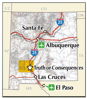
The Byway is in southwest New Mexico on Interstate 25, the Pan American Highway, that bisects the state from north to south. We are between two east-west highways, I-10 (1 hour south) and I-40 (2 hours north).
Two major airports, Albuquerque Sunport and El Paso International, are 2 hours away by car.
Albuquerque International Sunport
The Albuquerque Airport is 150 miles north of Truth or Consequences, just off I-25. From the Airport, drive south on I-25 and exit at Truth or Consequences on Exit 79. Proceed through town until the road divides into one-way downtown streets – you’ll be on Main once you enter downtown. Take a left on Foch Street. The Geronimo Trail Visitors and Interpretive Center is located between McAdoo & Sims streets. Parking is available on Foch and McAdoo streets.
El Paso International Sunport
The El Paso Airport is about 150 miles south of Truth or Consequences. From El Paso go north on I-10 to Las Cruces, NM and take I-25 north at the junction. Proceed north to Truth or Consequences, and take Exit 75 at Williamsburg. Follow the four-lane highway about a mile until it divides into one-way streets in downtown Truth or Consequences. You will be on Broadway. You will pass Davis Fleck Pharmacy on the right and the Bank of the Southwest on the left. Turn left on Foch Street; the Geronimo Trail Visitors Center is on the left (west) side of Foch, between Sims and McAdoo.
Visitor Services
Fueling Up
Fuel stations are abundant in Truth or Consequences and Elephant Butte. Gasoline is normally available in the communities of Winston (northern route) and on Old Highway 187 at the Hillsboro turnoff. With so few vendors selling fuel, you should check availability before making an extended drive on less than a full tank.
No fuel is available on the 36 mile trip from Hillsboro to San Lorenzo or on the 62 mile round trip between Winston and Beaverhead.
Lodging and Restaurants
You will find a complete and up-to-date listing of visitor services, including hotels and restaurants, at SierraCounty.info.
Activities
![]() Boating: Many types of boats (including jetskis and houseboats) are available for rent at one of Elephant Butte Lake’s 3 marinas. Both the Rio Grand Yacht Club and the Southwest Dragboat Association hold occasional tournaments and events. The annual Parade of Lights (second Saturday in December) is held in December, during Elephant Butte’s Luminaria Beachwalk event.
Boating: Many types of boats (including jetskis and houseboats) are available for rent at one of Elephant Butte Lake’s 3 marinas. Both the Rio Grand Yacht Club and the Southwest Dragboat Association hold occasional tournaments and events. The annual Parade of Lights (second Saturday in December) is held in December, during Elephant Butte’s Luminaria Beachwalk event.
![]() Camping: Over 300 developed campsites are available at Sierra County’s three State Parks — and there are hundreds more, both with and without services, at locations throughout the Gila National Forest.
Camping: Over 300 developed campsites are available at Sierra County’s three State Parks — and there are hundreds more, both with and without services, at locations throughout the Gila National Forest.
![]() Fishing: With New Mexico’s 2 largest lakes located here, as well as the Rio Grande and streams and smaller lakes of the Gila, fishing is one of the area’s most popular activities. In summer, American Bass tournaments, the Elephant Butte Kayak FIshing Tournament, and other fishing events attract crowds. An almost unlimited number of scenic spots are available for those wanting to fish from a watercraft or the shore. The Gila, although relatively dry, offers fishing in its many miles of perennial creeks and rivers as well as in man-made lakes. Some of the more common sport fish found in these waters include Rainbow and Brown Trout, Large and Small Mouth Bass as well as Channel and Flathead Catfish.
Fishing: With New Mexico’s 2 largest lakes located here, as well as the Rio Grande and streams and smaller lakes of the Gila, fishing is one of the area’s most popular activities. In summer, American Bass tournaments, the Elephant Butte Kayak FIshing Tournament, and other fishing events attract crowds. An almost unlimited number of scenic spots are available for those wanting to fish from a watercraft or the shore. The Gila, although relatively dry, offers fishing in its many miles of perennial creeks and rivers as well as in man-made lakes. Some of the more common sport fish found in these waters include Rainbow and Brown Trout, Large and Small Mouth Bass as well as Channel and Flathead Catfish.
![]() Golf: There are 2 golf courses along the Byway. Truth or Consequences’ Municipal Golf Course offers 9-holes, a putting green and a pitching green. Sierra del Rio Golf Course, an 18-hole course, sponsors regular tournaments. As a part of the new Turtleback Mountain Resort, Sierra del Rio offers a country club atmosphere at day use prices.
Golf: There are 2 golf courses along the Byway. Truth or Consequences’ Municipal Golf Course offers 9-holes, a putting green and a pitching green. Sierra del Rio Golf Course, an 18-hole course, sponsors regular tournaments. As a part of the new Turtleback Mountain Resort, Sierra del Rio offers a country club atmosphere at day use prices.
![]() There are 5 Museums on the Byway:
There are 5 Museums on the Byway:
Black Range Museum, Hillsboro; Geronimo Springs Museum, Truth or Consequences; Hamilton Military Museum at Veterans Memorial Park, Truth or Consequences; Kingston Schoolhouse Museum; and Pioneer Store Museum, Chloride.
![]() Hiking: Miles of hiking trails, nature walks and other walking spots are available on the Byway. The Gila National Forest has hundreds of miles of hiking trails, as well as a number of interpretive trails; 22 miles of the Continental Divide Trail run through the Aldo Leopold Wilderness and can be accessed from Highway 59 near Beaverhead or from the Rocky Canyon Campground near San Lorenzo.
Hiking: Miles of hiking trails, nature walks and other walking spots are available on the Byway. The Gila National Forest has hundreds of miles of hiking trails, as well as a number of interpretive trails; 22 miles of the Continental Divide Trail run through the Aldo Leopold Wilderness and can be accessed from Highway 59 near Beaverhead or from the Rocky Canyon Campground near San Lorenzo.
![]() Birding: Percha Dam State Park is one of the 5 top birding areas in the state. Percha, along with the other two State Parks on the Byway, are designated ”Audobon Important Birding Areas.” Approximately 337 bird species have been sighted in the Gila. The numerous species of birds is largely related to the diverse ecological habitat found on the Gila and location on a migratory flight path. Southwest New Mexico Birding information is online at www.wildlife.state.nm.us/recreation/birding sites numbered 30 through 37 are within the Byway. A Gila Bird Check List is available as a PDF.
Birding: Percha Dam State Park is one of the 5 top birding areas in the state. Percha, along with the other two State Parks on the Byway, are designated ”Audobon Important Birding Areas.” Approximately 337 bird species have been sighted in the Gila. The numerous species of birds is largely related to the diverse ecological habitat found on the Gila and location on a migratory flight path. Southwest New Mexico Birding information is online at www.wildlife.state.nm.us/recreation/birding sites numbered 30 through 37 are within the Byway. A Gila Bird Check List is available as a PDF.
![]() Biking: Bicycle traffic is common along the byway. Please keep a wide berth as you pass cyclists. Bicycle endurance races are held on NM-152 across the Black Range over Emory Pass, usually in May. This road is also on the southern Bike Centennial route across the U.S., attracting bicyclists from all over the world.
Biking: Bicycle traffic is common along the byway. Please keep a wide berth as you pass cyclists. Bicycle endurance races are held on NM-152 across the Black Range over Emory Pass, usually in May. This road is also on the southern Bike Centennial route across the U.S., attracting bicyclists from all over the world.
New Mexico Statewide Road Conditions
(24-hour service)
1-800-432-4269
The roads from Kingston all the way to Beaverhead may be closed after winter snowfalls, until plowed. Note that Forest Development Road 150 is never plowed, and driving on it in times of snow is forbidden. Check road conditions before leaving if any doubt of their being passable exists. Allow extra driving time for the curvy mountain roads in any event; you’ll have a better, more relaxed experience. If you encounter cattle on the highways or roads, remember – they have free range and the right-of-way.
Leave No Trace
You play an essential role in ensuring the ethical treatment and protection of irreplaceable archaeological resources. Archaeological sites throughout New Mexico offer us a unique opportunity to study the history of the Southwest as experienced and depicted by the people who lived it. Archaeological resources, both sites and collections on Federal and State Lands, are protected by the 1906 American Antiquities Act, the 1979 Archaeological Resources Protection Act (ARPA) and the 1990 Native American Graves Repatriation Act (NAGPRA).
Helpful Contacts
Geronimo Trail Scenic Byway Office
523 N. Broadway, Truth or Consequences NM 87901
info@geronimotrail.com
575-894-1968
Sierra County Sheriff’s Office
(most of the Geronimo Trail is in Sierra County)
575-894-6617
Grant County Sheriff’s Office
(the southwest corner of the Geronimo Trail is in Grant County west of Emory Pass.)
575-538-3797
Catron County Sheriff’s Office
(a small part of the Trail in the northwest corner is in Catron County including the Beaverhead Work Center)
575-533-6222
New Mexico State Police
888-442-6677
Black Range District, Gila National Forest
(the area of the Geronimo Trail in the Gila National Forest, generally)
1804 Date Street, Truth or Consequences NM 87901
https://www.fs.usda.gov/gila/
575-894-6677
Beaverhead Ranger Station
(located in the northern part of the Gila National Forest)
575-772-5747
Mimbres Wilderness Ranger District
(located in the southern part of the Gila National Forest)
3697 NM Highway 35 North, Mimbres NM 88049
575-536-2250
Sierra Vista Hospital
(Truth or Consequences)
800 East 9th Street, Truth or Consequences NM 87901
575-894-2111